
RELIABLE NAVIGATION IN GPS-DENIED MARITIME ENVIRONMENTS WITH THE ANELLO MARITIME INS
THE ANELLO X3 IMU - UNLOCKING RELIABLE FLIGHT IN GPS-DENIED AIRSPACE
EXECUTIVE SUMMARY
As autonomous and crewed vessels increasingly operate in GPS-contested waters, reliable navigation during GPS jamming and spoofing becomes essential for mission continuity. The ANELLO Maritime INS, powered by the Silicon Photonics Optical Gyroscope (SiPhOG™), delivers resilient, low-drift navigation performance in GPS-denied environments, ensuring precise positioning and control for defense and commercial maritime operations.
BACKGROUND
Maritime navigation depends heavily on GNSS signals for accuracy and safety. However, GPS interference, whether from spoofing, jamming, or multipath effects poses a growing challenge near ports, coastlines, and in active EW (Electronic Warfare) zones. The ANELLO Maritime INS was tested in multiple real-world scenarios to validate its performance under GPS degradation and total loss, maintaining course stability and minimal drift across diverse environments.
SYSTEM ARCHITECTURE & TEST SETUP
Platform: Unmanned Surface Vessel (USV) with integrated navigation and control suite
Sensors: ANELLO Maritime INS, GNSS antennae, paddle wheel
Interfaces: RS-232 serial connection to onboard controller
Software: ANELLO-supplied X3 driver, PX4 and ArduPilot are supported
Test Sites: San Diego Bay, CA and Middle East coastal environment

TEST DATA
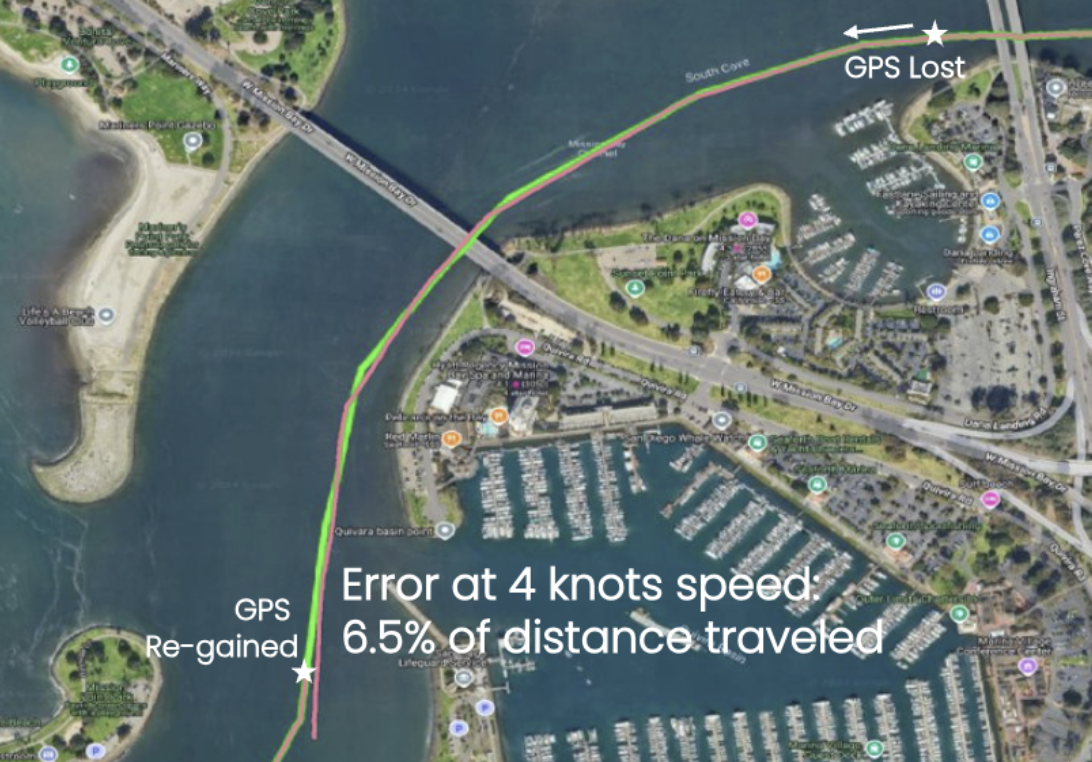
Figure 1: Coastal test ‒ GPS lost/re-gained with 6.5% total drift over distance traveled at 4 knots.
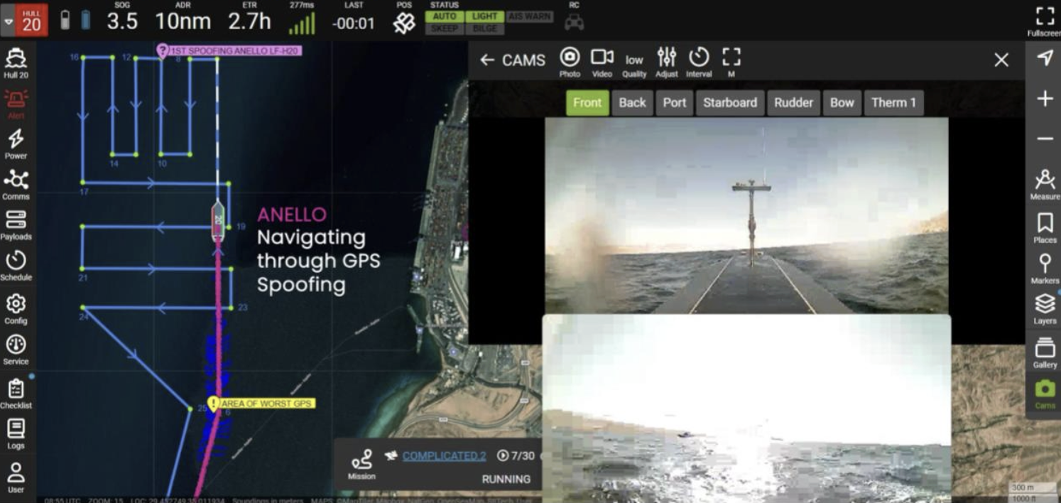
Figure 2: ANELLO Maritime INS navigating through GPS spoofing and signal degradation.
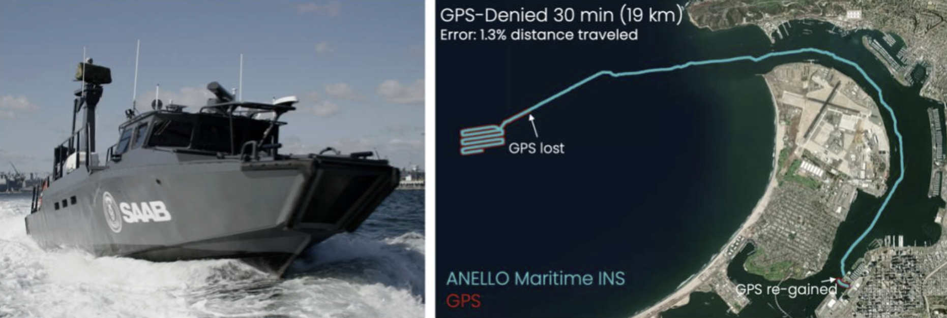
Figure 3: Figure 3: SAAB USV demonstration ‒ 30-minute GPS-denied operation with only 1.3% total drift.
RESULTS
Stable navigation during GPS outages and spoofing events
Drift contained to 6.5% of total distance over low-speed coastal test
Drift of only 1.3% during a 30-minute (19 km) GPS-denied operation
Seamless reintegration once GPS was re-gained without position jumps
Consistent heading and velocity estimation under harsh maritime conditions
PERFORMANCE ADVANTAGES
Reliable continuity through GPS loss or spoofing zones
Tight-drift control for extended GPS-denied navigation
Rapid re-alignment upon GPS recovery
Drop-in integration with existing marine control systems
Optical-grade inertial performance with no moving parts
CONCLUSION & NEXT STEPS
The ANELLO Maritime INS delivers a battle-tested, high-precision inertial navigation solution engineered for vessels operating in GPS-contested and denied environments. Leveraging ANELLO's proprietary SiPhOG™ silicon photonic optical gyroscope technology, the system ensures continuous navigation accuracy and operational integrity in the face of spoofing, jamming, or complete signal loss.
As maritime operations increasingly encounter electronic warfare threats and navigation disruption, the ANELLO Maritime INS provides the resilience required to maintain mission-critical positioning and heading data independent of external satellite signals. The system's proven performance in operational deployments has established it as a trusted solution for defense platforms, autonomous maritime vehicles, and commercial fleets requiring assured navigation in challenging environments.
ANELLO continues to advance maritime navigation capabilities through ongoing testing programs and integration partnerships with defense contractors, autonomous vessel developers, and commercial maritime operators worldwide.
For technical specifications, integration guidance, or partnership inquiries, contact ANELLO Photonics at info@anellophotonics.com.